 1
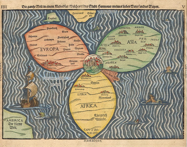
1title: Die gantze Welt in einem Kleberblat / Welches ist der Stadt Hannover meines lieben Vaterlandes Wapen "The entire world in the shape of a clover-leaf, which is the emblem of the city of Hannover, my beloved homeland"
artist: Heinrich Bünting
date: 1581
medium: technique woodcut
source: [link]
credit: [1]
description:
Stylized world map in the shape of a clover-leaf (the three classical continents of europe, Asia, Africa), with Jerusalem at the center, with additional indication of Great Britain, Scandinavia and America / the New World. Page 4f. of Die eigentliche und warhafftige gestalt der Erden und des Meers (1581), printed in Magdeburg.license:Public domain
 2
2title: 1860 Mitchell Map of Europe Geographicus - Europe-m-63
artist: Samuel Augustus Mitchell
date: 1860
dimensions: Size unit=in width=14 height=11
source: Mitchell Jr., S. A., <i>Mitchell's New General Atlas, Containing Maps Of The Various Countries Of The World, Plans Of Cities, Etc. Embraced In Forty-Seven Quarto Maps, Forming A Series Of Seventy-Six Maps And Plans, Together With Valuable Statistical Tables.</i> (1860 First Edition) Geographicus-source
credit: This file was provided to Wikimedia Commons by Geographicus Rare Antique Maps, a specialist dealer in rare maps and other cartography of the 15th, 16th, 17th, 18th and 19th centuries, as part of a cooperation project.
description: This hand colored map is a copper plate engraving, dating to 1860 by the legendary American Mapmaker S.A. Mitchell, the younger. It represents all of europe including the British Isles, Scandinavia, and Russia. Shows both political and geographical features. map is dated and copyrighted, 1860.
license:Public domain
 3
3title: 1862 Johnson Map of Europe Geographicus - Europe-johnson-1862
artist: Alvin Jewett Johnson
date: 1862 (undated)
dimensions: Size unit=in width=24 height=17.5
source: Johnson, A. J., <i>Johnson's New Illustrated (Steel Plate) Family Atlas with Descriptions, Geographical, Statistical, and Historical.</i> (1862 A. J. Johnson & Ward edition) Geographicus-source
credit: This file was provided to Wikimedia Commons by Geographicus Rare Antique Maps, a specialist dealer in rare maps and other cartography of the 15th, 16th, 17th, 18th and 19th centuries, as part of a cooperation project.
description: A very beautiful example of Johnson's 1862 map of europe. This two part map details all of europe as well as adjacent parts of Asia and Africa. Highly detailed with countless place names. Also shows the starting points and routes of numerous famous explorers including Byron, Cook, the Resolution, Vancouver, Isabella & Alexander, Carteret, Wallis and others. Color coded according to country and region. This europe map appeared only in the 1860 - 1862 editions of Johnson's Atlas and was replaced with a new plate in 1863. Features the strapwork style border common to Johnson’s atlas work from 1860 to 1863. Published by A. J. Johnson and Ward as plate numbers 67-68 in the 1862 edition of Johnson’s New Illustrated Family Atlas . This is the first edition of the Family Atlas to bear the Johnson and Ward imprint.
license:Public domain
 4
4title: 1850 Mitchell Map of Europe Geographicus - Europe-mitchell-1850
artist: Samuel Augustus Mitchell
date: 1850 (dated)
dimensions: Size unit=in width=15.5 height=12.5
source: Mitchell Sr., S. A.,<i>A New Universal Atlas Containing Maps of the various Empires, Kingdoms, States and Republics Of The World.</i> (1850 issue) Geographicus-source
credit: This file was provided to Wikimedia Commons by Geographicus Rare Antique Maps, a specialist dealer in rare maps and other cartography of the 15th, 16th, 17th, 18th and 19th centuries, as part of a cooperation project.
description: An attractive example of S. A. Mitchell Sr.’s 1850 map of europe. Depicts the entire continent color coded according to individual countries. Surrounded by the green border common to Mitchell maps from the 1850s. Prepared by S. A. Mitchell for issued as plate no. 45 in the 1850 edition of his New Universal Atlas . Dated and copyrighted, “Entered according to act of Congress, in the year 1850, by Thomas Cowperthwait & Co., in the Clerks office of the District court of the Eastern District of Pennsylvania.
license:Public domain
 5
5title: 1818 Pinkerton Map of of Europe Geographicus - Europe-pinkerton-1818
artist: John Pinkerton
date: 1818 (undated)
dimensions: Size unit=in width=28 height=20.5
source: Pinkerton, J., <i>A Modern Atlas, from the Lates and Best Authorities, Exhibiting the Various Divisions of the World with its chief Empires, Kingdoms, and States; in Sixty Maps, carefully reduced from the Larges and Most Authentic Sources.</i> 1818, Philadelphia, Thomas Dobson Edition. Geographicus-source
credit: This file was provided to Wikimedia Commons by Geographicus Rare Antique Maps, a specialist dealer in rare maps and other cartography of the 15th, 16th, 17th, 18th and 19th centuries, as part of a cooperation project.
description: Pinkerton's extraordinary 1818 map of europe. Covers europe at the beginning of the 19th century. Offers considerable detail with political divisions and color coding at the regional level. Identifies cities, towns, castles, swamps, mountains and river ways. Title plate in the upper left quadrant. A mile scale in British Statute Miles also appears in the upper left quadrant. Drawn by L. Herbert and engraved by Samuel Neele under the direction of John Pinkerton. This map comes from the scarce American edition of Pinkerton’s Modern Atlas, published by Thomas Dobson & Co. of Philadelphia in 1818.
license:Public domain
 6
6title: 1864 Johnson Map of Europe Geographicus - Europe-johnson-1864
artist: Alvin Jewett Johnson
date: 1864 (undated)
dimensions: Size unit=in width=23.5 height=17.5
source: Johnson, A. J., <i>Johnson's New Illustrated (Steel Plate) Family Atlas of The World with Physical Geography, and with Descriptions Geographical, Statistical, and Historic including The Latest Federal Census, A Geographical Index, and a Chronological History of the Civil War in America</i>, (first Johnson and Ward), 1864. Geographicus-source
credit: This file was provided to Wikimedia Commons by Geographicus Rare Antique Maps, a specialist dealer in rare maps and other cartography of the 15th, 16th, 17th, 18th and 19th centuries, as part of a cooperation project.
description: A. J. Johnson’s beautifully hand colored 1864 map of europe. This map shows cities, topographical features, railways, ferries and roads with color coding at the regional level. The routes of various explorers, including Cook, Byron, Carteret, and others, are shown. In contrast to most Johnson maps, the sea is here rendered in a pale blue. This is the last edition of this map, which harkens back to Johnson’s 1860 europe, to be released before Johnson re-engraved his continental map places in the later part of 1864. Published by A. J. Johnson and Ward as plates 72-73 in the 1864 edition of Johnson’s New Illustrated Family Atlas . This is the first edition of the Johnson’s Atlas to bear the Johnson & Ward imprint and the only edition to identify the firm as the “Successors to Johnson and Browning (Successors to J. H. Colton and Company)”.
license:Public domain
![europe map ["WWII: Europe: France; “",{"type":"a","key":"1","ref":null,"props":{"href":"https://en.wikipedia.org/wiki/Into_the_Jaws_of_Death","className":"extiw","title":"en:Into the Jaws of Death","children":"Into the Jaws of Death"},"_owner":null}," — U.S. Troops wading through water and Nazi gunfire”, ",{"type":"i","key":"3","ref":null,"props":{"children":"circa"},"_owner":null}," 1944-06-06."] europe map - image 7](https://upload.wikimedia.org/wikipedia/commons/thumb/a/a5/Into_the_Jaws_of_Death_23-0455M_edit.jpg/746px-Into_the_Jaws_of_Death_23-0455M_edit.jpg) 7
7title: WWII: Europe: France; “Into the Jaws of Death — U.S. Troops wading through water and Nazi gunfire”, circa 1944-06-06.
artist:
Chief Photographer's Mate (CPHoM) Robert F. Sargentdate: 1944-06-06 08:30
current location: Institution:NARA Franklin D. Roosevelt Library (NLFDR), 4079 Albany Post Road, Hyde Park, NY, 12538-1999.
source: NARA-image|id=195515 High resolution file from link
credit: This media is available in the holdings of the National Archives and Records Administration, cataloged under the National Archives Identifier (NAID) 195515.
license:Public domain
 8
8title: Map showing the Cephalic Index of Europe Wellcome L0072218
artist: unknown
source: link * Gallery: link * Wellcome Collection gallery (2018-03-31): link [link CC-BY-4.0]
credit: link Gallery: link Wellcome Collection gallery (2018-03-31): link CC-BY-4.0
description:
"The races of europe : a sociological study (Lowell Institute lectures)" by William Z. Ripley. map showing the Cephalic Index of europe, between pages 52-53
Rare Books
Keywords: Civilization; Ethnology; Cities; Acclimatizationlicense:
CC BY 4.0
 9
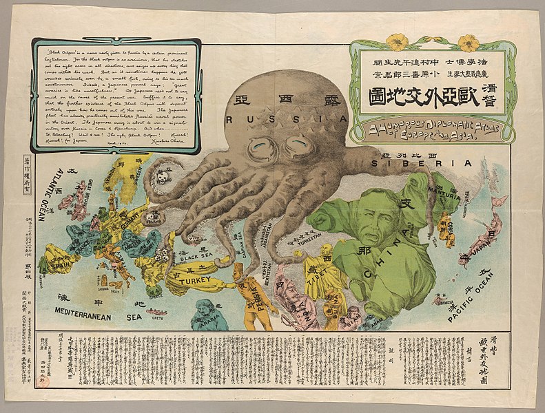
9title: Kisaburō Ohara, Europe and Asia Octopus Map, 1904 Cornell CUL PJM 1145 01
artist:
Ohara, Kisaburōdate: 1904
dimensions: (cm, H x W) 42 x 57
current location: Institution:Cornell University Library
source: Harmon 2004, 116-17
[link Cornell University: Persuasive Cartography: The PJ Mode Collection]credit: Harmon 2004, 116-17
Cornell University: Persuasive Cartography: The PJ Mode Collectiondescription: An anti-Russian satirical map produced by a Japanese student at Keio University during the Russo-Japanese War. Manturia / China / Tibet / Turkestan / Formosa
license:Public domain

title: Navigational Map of Europe 1885P1759
artist:
date: 1528
current location: Institution:Birmingham Museum and Art Gallery
source: Birmingham Museum and Art Gallery
credit: Birmingham Museum and Art Gallery
description: map by Jacobo Russo
license:Public domain


