 1
1title: 1858 Dispatch Atlas Map of Egypt, Nubia, Abyssinia and the Red Sea Geographicus - EgyptNubia-dispatch-1858
artist: link
date: 1858 (dated)
dimensions: Size unit=in width=17 height=24.5
source: <i>Cassell’s Weekly Dispatch Atlas</i> c. 1858. Geographicus-source
credit: This file was provided to Wikimedia Commons by Geographicus Rare Antique Maps, a specialist dealer in rare maps and other cartography of the 15th, 16th, 17th, 18th and 19th centuries, as part of a cooperation project.
description: This is a hand colored map of egypt, Nubia and Abyssinia, dating to 1858, by London cartographer Edward Weller. Depicts northeastern Africa from what is today central Ethiopia, northward along the Nile to egypt and the Delta. Shows the Red Sea in full along with parts of Saudi Arabia. An inset in the upper right quadrant details the Nile Delta and egypt’s Central Valley. Notes Mount Sinai as well as the location of many ancient Egyptian ruins. Originally part of the Weekly Dispatch Atlas, whose September 19th, 1958 stamp still appears on the top left of the map.
license:Public domain
 2
2title: 1805 Cary Map of Egypt Geographicus - Egypt-cary-1805
artist: John Cary
date: 1805 (dated)
dimensions: Size unit=in width=21.5 height=19.25
source: Cary, John, Cary's New Universal Atlas, containing distinct maps of all the principal states and kingdoms throughout the World. From the latest and best authorities extant. London: Printed for J. Cary, Engraver and map-seller, No. 181, near Norfolk Street, Strand, 1808. Geographicus-source
credit: This file was provided to Wikimedia Commons by Geographicus Rare Antique Maps, a specialist dealer in rare maps and other cartography of the 15th, 16th, 17th, 18th and 19th centuries, as part of a cooperation project.
description: An exceptionally beautiful example of John Cary’s important 1805 map of the egypt. Covers egypt in extraordinary detail focusing on the course of the Nile River Valley from the Delta region south to Aswan. Notes the sites of numerous riverside villages and cities as well as important ancient Egyptian ruins, Coptic and Abyssinian Monasteries, and important caravan routes between important desert oases. Also notes the locations of both Mt. Horeb and Mount Sinai, in the Sinai Peninsula. The left hand side of the map is dominated by a large inset of the Nile Delta region. This wonderful inset offers details on ancient ruins and European explorations in the region as well as noting numerous delta cities, villages, and trade routes. All in all, one of the most interesting and attractive atlas maps of egypt to appear in first years of the 19th century. Prepared in 1805 by John Cary for issue in his magnificent 1808 New Universal Atlas .
license:Public domain
 3
3title: 1771 Bonne Map of Arabia Geographicus - Arabia-bonne-1771
artist: Rigobert Bonne
date: 1771 (dated)
dimensions: Size unit=in width=18.25 height=12.5
source: Lattre, Jean, <i>Atlas Moderne ou Collection de Cartes sur Toutes les Parties du Globe Terrestre</i>, c. 1775. Geographicus-source
credit: This file was provided to Wikimedia Commons by Geographicus Rare Antique Maps, a specialist dealer in rare maps and other cartography of the 15th, 16th, 17th, 18th and 19th centuries, as part of a cooperation project.
description: A beautiful example of Rigobert Bonne's 1771 decorative map of the Arabian Peninsula. Covers from the Mediterranean to the Indian Ocean and from the Red Sea to the Persian Gulf. Includes the modern day nations of Saudi Arabia, Palestine, Jordan, Kuwait, Iraq, Yemen, Oman, the United Arab Emirates, and Bahrain. Names Mt. Sinai, Mecca and Jerusalem as well as countless other cities and desert oases. Also notes numerous offshore shoals, reefs, and other dangers in the Red Sea and the Persian Gulf. There is a large decorative title cartouche in the upper right hand quadrant. A fine map of the region. Drawn by R. Bonne in 1771 for issue as plate no. A 25 in Jean Lattre's 1776 issue of the Atlas Moderne .
license:Public domain
 4
4title: 1762 Bonne Map of Egypt Geographicus - Egypt-bonne-1762
artist: Rigobert Bonne
date: 1762 (dated)
dimensions: Size unit=in width=12.5 height=18
source: Lattre, Jean, <i>Atlas Moderne ou Collection de Cartes sur Toutes les Parties du Globe Terrestre</i>, c. 1775. Geographicus-source
credit: This file was provided to Wikimedia Commons by Geographicus Rare Antique Maps, a specialist dealer in rare maps and other cartography of the 15th, 16th, 17th, 18th and 19th centuries, as part of a cooperation project.
description: A beautiful example of Rigobert Bonne's 1762 decorative map egypt. Covers from the Nile Delta south as far as Aswan and the border with Nubia and includes the Sinai and parts of the Red Sea. Makes note of both ancient and modern (c. 1762) sites. Details various Sheikdoms, Prefectures and Provinces throughout. An elaborate decorative title cartouche in the upper right quadrant features stylized date palms, the Nile cataracts, and a typically monstrous Nile crocodile. Drawn by R. Bonne in 1762 for issue as plate no. 29 in Jean Lattre's 1776 issue of the Atlas Moderne .
license:Public domain
 5
5title: 1818 Pinkerton Map of Egypt Geographicus - Egypt-pinkerton-1818
artist: John Pinkerton
date: 1818 (undated)
dimensions: Size unit=in width=20.5 height=28
source: Pinkerton, J., <i>A Modern Atlas, from the Lates and Best Authorities, Exhibiting the Various Divisions of the World with its chief Empires, Kingdoms, and States; in Sixty Maps, carefully reduced from the Larges and Most Authentic Sources.</i> 1818, Philadelphia, Thomas Dobson Edition. Geographicus-source
credit: This file was provided to Wikimedia Commons by Geographicus Rare Antique Maps, a specialist dealer in rare maps and other cartography of the 15th, 16th, 17th, 18th and 19th centuries, as part of a cooperation project.
description: Pinkerton's extraordinary 1818 map of egypt. Covers the region centered on the Nile River from its delta along the Mediterranean south to the Island of Philae and the city of Aswan. Notes numerous cities and villages along the river as well as various ancient Egyptian ruins including the Pyramids of Giza and the temples of ancient Thebes. Also offers considerable detail the Valley of Natron with is numerous important Coptic monasteries. Several desert oases are also noted, including Fayoum, Parva (Kharga) and Haled. In the Red Sea, the Gulf of Suez, and the Gulf of Aqaba, several undersea shoals and reefs are noted. Also notes Mountain Sinai. Identifies cities, towns, castles, swamps, mountains and river ways. Title plate in the lower left quadrant. Two mile scales, in Arabian Miles and British Statute Miles, also appear in the lower left quadrant. Drawn by L. Herbert and engraved by Samuel Neele under the direction of John Pinkerton. This map comes from the scarce American edition of Pinkerton’s Modern Atlas, published by Thomas Dobson & Co. of Philadelphia in 1818.
license:Public domain
 6
6title: 1827 Finley Map of Egypt Geographicus - Egypt-finley-1827
artist: Anthony Finley
date: 1827 (undated)
dimensions: Size unit=in width=9 height=11.5
source: Finley, Anthony, <i>A New General Altas, Comprising a Complete Set of Maps, representing the Grand Divisions of the Globe, Together with the several Empires, Kingdoms and States in the World; Compiled from the Best Authorities, and corrected by the Most Recent Discoveries</i>, Philadelphia, 1827. Geographicus-source
credit: This file was provided to Wikimedia Commons by Geographicus Rare Antique Maps, a specialist dealer in rare maps and other cartography of the 15th, 16th, 17th, 18th and 19th centuries, as part of a cooperation project.
description: A beautiful example of Finley's important 1827 map of egypt. Depicts egypt, centered on the Nile River, and extending south as far as Aswan. Names numerous settlements and villages along the course of the river, including a number of temples and ancient Egyptian ruins. Also identifies several desert Oases including Parva (Kharga?) and Shekh Huled (Dakhla?). In the Sinai Peninsula, a mountain labeled Gebel Tour, Mt. Sinai or Horeb is drawn. Title and scale in lower left quadrant. Engraved by Young and Delleker for the 1827 edition of Anthony Finley's General Atlas .
license:Public domain
 7
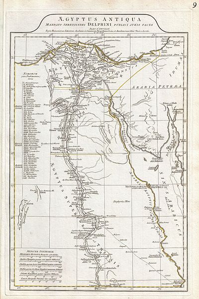
7title: 1794 Anville Map of Ancient Egypt Geographicus - Egypt-anville-1794
artist: Jean Baptiste Bourguignon d'Anville
date: 1794 (dated)
dimensions: Size unit=in width=12.5 height=20
source: D'Anville, J. B. B., <i>Complete Body of Ancient Geography</i>, Laurie and Whittle, London, 1795. Geographicus-source
credit: This file was provided to Wikimedia Commons by Geographicus Rare Antique Maps, a specialist dealer in rare maps and other cartography of the 15th, 16th, 17th, 18th and 19th centuries, as part of a cooperation project.
description: A large and dramatic 1794 J. B. B. D'Anville map of Ancient egypt Covers from the Nile Delta and Gaza south as far as Aswan. Details mountains, rivers, cities, roadways, and lakes with political divisions highlighted in outline color. Features both ancient and contemporary place names, ie. Thebae and Luxor, for each destination - an invaluable resource or scholars of antiquity. Identifies the Pyramids, Mount Sinai, Natron, Philae Island, the Cataracts, etc. Title area appears in a raised zone above the map proper. Includes six distance scales, bottom left, referencing various measurement systems common in antiquity. Text in Latin and English. Drawn by J. B. B. D'Anville in 1762 and published in 1794 by Laurie and Whittle, London.
license:Public domain
 8
8title: 1855 Colton Map of Turkey, Iraq, and Syria Geographicus - TurkeyIraq-colton-1855
artist: J. H. Colton
date: 1855 (dated)
dimensions: Size unit=in width=16.5 height=13
source: Colton, G. W., <i>Colton's Atlas of the World Illustrating Physical and Political Geography</i>, Vol 2, New York, 1855 (First Edition). Geographicus-source
credit: This file was provided to Wikimedia Commons by Geographicus Rare Antique Maps, a specialist dealer in rare maps and other cartography of the 15th, 16th, 17th, 18th and 19th centuries, as part of a cooperation project.
description: A beautiful 1855 first edition example of Colton's map of the Ottoman Empire (Turkey) in Asia and the Caucuses.
- Covers from the Crimea south to the Nile Delta, west as far as the Aegean, and east to the Caspian Sea and the Persian Gulf.
- Basically covers the mid 19th century claims of the Ottoman Empire, however, includes the modern nations of Turkey, Iraq, Kuwait, Syria, Jordan, Israel or Palestine, Armenia, Georgia, and Azerbaijan, with parts of adjacent Iran, Greece, egypt and Ukraine.
- Throughout the map, Colton identifies various cities, towns, forts, rivers, desert oases, and an assortment of additional topographical details. Surrounded by Colton's typical spiral motif border.
- Dated and copyrighted to J. H. Colton, 1855. Published from Colton's 172 William Street Office in New York City. Issued as page no. 25 in volume 2 of the first edition of George Washington Colton's 1855 Atlas of the World .
license:Public domain
 9
9title: Unknown, Egypt, 15th Century Map of World - Google Art Project
artist: Unknown, egypt, 15th Century (egypt)
date: (1400 - 1500)
dimensions: h 181 cm
current location: The Museum of Islamic Art, Qatar
credit: xgHBeFmpyqjP_A at Google Cultural Institute maximum zoom level
license:Public domain

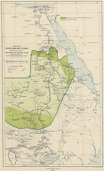
title: MILNER(1894) MAP OF EGYPT AND THE SUDAN
artist: unknown
date: 1894
source: Image extracted from page 481 of ''England in egypt'', by MILNER, Alfred - Viscount Milner. Original held and digitised by the British Library. Copied [link from Flickr]. ''Note: The colours, contrast and appearance of these illustrations are unlikely to be true to life. They are derived from scanned images that have been enhanced for machine interpretation and have been altered from their originals.'' Mechanical Curator image
credit: This file is from the Mechanical Curator collection, a set of over 1 million images scanned from out-of-copyright books and released to Flickr Commons by the British Library.
View in BL Georeferencer View image on Flickr View all images from book
View catalogue entry for book.license:Public domain


