 1
1title: Claudius Ptolemy- The World
artist:
Lord Nicolas the German (Donnus Nicholas Germanus), cartographer
Johann the Blockcutter of Armsheim (Johannes Schnitzer or Johannes de Armssheim), engraverdate: 1482
source: Decorative Maps by Roderick Barron - ISBN|1851702989
credit: Decorative Maps by Roderick Barron - ISBN 1851702989
description: The world map">world map from Leinhart Holle's 1482 edition of Nicolaus Germanus's emendations to Jacobus Angelus's 1406 Latin translation of Maximus Planudes's late-13th century rediscovered Greek manuscripts of Ptolemy's 2nd-century Geography.
license:Public domain
 2
2title: Catherine de Médicis Louvre
artist:
date: circa 1580 (1550-1599)
medium: Technique oil oak panel
dimensions: Size cm 30 25
current location: Richelieu, LangSwitch :Museum:Louvre
source: [[User:Siren-Com|Siren-Com]]
credit: Siren-Com
license:Public domain
 3
3title: 1875 Meiji 8 Japanese Map of the World Geographicus - World-meiji8-1875
artist: link
date: 1875 (dated: Meiji 8)
dimensions: Size unit=in width=36 height=28
source: Pocket Map (Independent Issue) Geographicus-source
credit: This file was provided to Wikimedia Commons by Geographicus Rare Antique Maps, a specialist dealer in rare maps and other cartography of the 15th, 16th, 17th, 18th and 19th centuries, as part of a cooperation project.
description: An exceedingly rare find. This is a Japanese map of the world dated to the 8th year of the Emperor’s Meiji’s reign, or 1897. Depicts the entire world on a hemisphere projection with smaller polar projections in the upper left and right quadrants. The national boundaries and geography in general is vague, as is common to Japanese maps of this period. Color coded according to region with Japan itself in bright red. Several harbor plans and views adorn the bottom portions of the map. All text in Japanese. Folds into its original boards.
license:Public domain
4
title: 0 Marie de Médicis Frans Pourbus le Jeune - Louvre (INV1710) - (2)
artist: Frans Pourbus the Younger
date: 1610
medium: Oil on canvas
dimensions: Size cm 307 186
current location: Institution:Louvre-Lens Prêt du Institution:Louvre
source: [[User:Jean-Pol GRANDMONT|User:Jean-Pol GRANDMONT]] (2013)
credit: User:Jean-Pol GRANDMONT (2013)
license:Public domain
5
title: 0 Marie de Médicis Frans Pourbus le Jeune - Louvre (INV1710) - (1)
artist: Frans Pourbus the Younger
date: 1610
medium: Oil on canvas
dimensions: Size cm 307 186
current location: Institution:Louvre-Lens Prêt du Institution:Louvre
source: [[User:Jean-Pol GRANDMONT|User:Jean-Pol GRANDMONT]] (2013)
credit: User:Jean-Pol GRANDMONT (2013)
license:Public domain
 6
6title: Falmouth Harbour - Lord Burghley's Atlas (1579), ff.15v-16 - BL Royal MS 18 D III
artist: Christopher Saxton
date: 1579
current location: Institution:British Library
source: Image taken from Lord Burghley's atlas Originally published/produced in London, 1579. BritishLibraryImageServices|id=c13233-28 |flickr=12459585214 British Library image |url=|ms-shelfmark=Royal MS 18 D III |cim-msid=|cim-coll=16 |cim-nstart=180403 |dips=|ms-digi=|hasLicense=yes
credit: This file has been provided by the British Library from its digital collections.
Catalogue entry: Royal MS 18 D III
- Illustrated cataloguelicense:
CC0
 7
7title: 1375 Atlas Catalan Abraham Cresques
artist: Abraham Cresques
date: 1375
source: [link Bibliothèque Nationale de France]
credit: Bibliothèque Nationale de France
description: atlas from the 14th century attributed to Abraham Cresques.
license:Public domain
 8
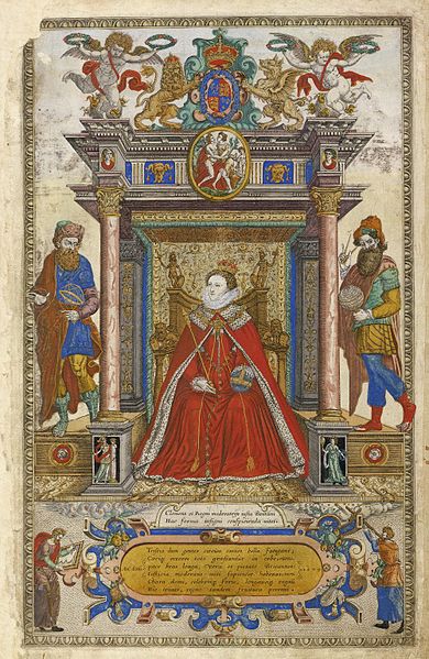
8title: Saxton's Frontispiece
artist:
date: 1579
current location: [[Wikipedia:Folger Shakespeare Library|Folger Shakespeare Library]]
source: Folger Shakespeare Library Digital Image Collection
credit: Folger Shakespeare Library Digital Image Collection
description: Frontispiece to Saxton's atlas of the Counties of England and Wales
license:
CC BY-SA 4.0
 9
9title: Cedid Atlas Title Page
artist: Mühendishane Matbaası (publisher)
date: 1803
medium: technique drawing mounted=paper
dimensions: Size unit=cm width=53 height=36
source: Creator: Bassem Fleifel
credit: Original source
description: Cedid atlas Title Page, the first modern atlas to be published in the Ottoman Empire and the Muslim world.
license:Public domain

title: John Singer Sargent Sketch for Atlas and the Hesperides - 29.138 - Museum of Fine Arts
artist: John Singer Sargent
credit: link
license:Public domain


