 1
1title: Leonardo da Vinci (1452 1519) - The Last Supper (1495-1498)
artist: Leonardo da Vinci
date: from 1495 until 1498
medium: Langswitch en=tempera on gesso, pitch and mastic
dimensions: size cm 460 880
current location: Institution:Convent of Santa Maria delle Grazie, Milan
license:Public domain
 2
2title: 1771 Bonne Map of Arabia Geographicus - Arabia-bonne-1771
artist: Rigobert Bonne
date: 1771 (dated)
dimensions: Size unit=in width=18.25 height=12.5
source: Lattre, Jean, <i>Atlas Moderne ou Collection de Cartes sur Toutes les Parties du Globe Terrestre</i>, c. 1775. Geographicus-source
credit: This file was provided to Wikimedia Commons by Geographicus Rare Antique Maps, a specialist dealer in rare maps and other cartography of the 15th, 16th, 17th, 18th and 19th centuries, as part of a cooperation project.
description: A beautiful example of Rigobert Bonne's 1771 decorative map of the Arabian Peninsula. Covers from the Mediterranean to the Indian Ocean and from the Red Sea to the Persian Gulf. Includes the modern day nations of Saudi Arabia, Palestine, Jordan, Kuwait, Iraq, Yemen, Oman, the United Arab Emirates, and Bahrain. Names Mt. Sinai, Mecca and Jerusalem as well as countless other cities and desert oases. Also notes numerous offshore shoals, reefs, and other dangers in the Red Sea and the Persian Gulf. There is a large decorative title cartouche in the upper right hand quadrant. A fine map of the region. Drawn by R. Bonne in 1771 for issue as plate no. A 25 in Jean Lattre's 1776 issue of the Atlas Moderne .
license:Public domain
 3
3title: 1855 Colton Map of Turkey, Iraq, and Syria Geographicus - TurkeyIraq-colton-1855
artist: J. H. Colton
date: 1855 (dated)
dimensions: Size unit=in width=16.5 height=13
source: Colton, G. W., <i>Colton's Atlas of the World Illustrating Physical and Political Geography</i>, Vol 2, New York, 1855 (First Edition). Geographicus-source
credit: This file was provided to Wikimedia Commons by Geographicus Rare Antique Maps, a specialist dealer in rare maps and other cartography of the 15th, 16th, 17th, 18th and 19th centuries, as part of a cooperation project.
description: A beautiful 1855 first edition example of Colton's map of the Ottoman Empire (Turkey) in Asia and the Caucuses.
- Covers from the Crimea south to the Nile Delta, west as far as the Aegean, and east to the Caspian Sea and the Persian Gulf.
- Basically covers the mid 19th century claims of the Ottoman Empire, however, includes the modern nations of Turkey, Iraq, Kuwait, Syria, Jordan, Israel or Palestine, Armenia, Georgia, and Azerbaijan, with parts of adjacent Iran, Greece, Egypt and Ukraine.
- Throughout the map, Colton identifies various cities, towns, forts, rivers, desert oases, and an assortment of additional topographical details. Surrounded by Colton's typical spiral motif border.
- Dated and copyrighted to J. H. Colton, 1855. Published from Colton's 172 William Street Office in New York City. Issued as page no. 25 in volume 2 of the first edition of George Washington Colton's 1855 Atlas of the World .
license:Public domain
 4
4title: 1866 Johnson Map of Arabia, Persia, Turkey and Afghanistan (Iraq) Geographicus - Arabia-johnson-1866
artist: Alvin Jewett Johnson
date: 1866 (undated)
dimensions: Size unit=in width=16.5 height=13
source: Johnson, A. J., <i>Johnson's New Illustrated Family Atlas of The World with Physical Geography, and with Descriptions Geographical, Statistical, and Historic including The Latest Federal Census, A Geographical Index, and a Chronological History of the Civil War in America</i>, 1866. Geographicus-source
credit: This file was provided to Wikimedia Commons by Geographicus Rare Antique Maps, a specialist dealer in rare maps and other cartography of the 15th, 16th, 17th, 18th and 19th centuries, as part of a cooperation project.
description: A very nice example of A. J. Johnson’s 1866 map of Arabia, Persia and Turkey in Asia. Covers from the Mediterranean and Egypt eastwards as far as the Mouths of the Indus River, as well as southward as far as the Horn of Africa and northwards to the Black Sea. Depicts most of the politically volatile modern day middle east, including the nations of Afghanistan, Iraq, Iran, Saudi Arabia, Jordan, Israel, Syria, Lebanon and Turkey. Offers color coding according to country and region as well as notations regarding desert caravan routes, oases, roadways, river systems, forts and monasteries, and some topographical features. Ostensibly this map is very similar to Colton's 1858 map of the same region, however, there are a number of significant differences. Johnson reduced Colton's original map in order to expand the map westward by about 10 degrees, making it possible for him to incorporate all of Turkey as well as add significant detail in northwestern Africa and the Nile Valley. Johnson's retooling of the map also allowed for the addition of his three attractive woodcut views: Muscat (lower left), Trebisond (lower left) and the Castle and Port of Smyrna (lower right). Features the fretwork style border common to Johnson’s atlas work from 1864 to 1869. Published by A. J. Johnson and Ward as plate number 95 in the 1865 edition of Johnson’s New Illustrated Family Atlas. This is the last edition of the Family Atlas to bear the Johnson and Ward imprint.
license:Public domain
 5
5title: 1724 De L'Isle Map of Persia (Iran, Iraq, Afghanistan) Geographicus - Persia-delisle-1724
artist: Guillaume Delisle
date: 1724 (undated)
dimensions: Size unit=in width=25 height=20
source: De L'Isle, G., <i>Atlas de Geographie</i>, c. 1730. Geographicus-source
credit: This file was provided to Wikimedia Commons by Geographicus Rare Antique Maps, a specialist dealer in rare maps and other cartography of the 15th, 16th, 17th, 18th and 19th centuries, as part of a cooperation project.
description: A fine first edition example of Guillaume De L’Isle’s important 1724 map of Persia. Covers from the Crimea and the Sea of Azov south to the Persian Gulf and the Straight of Ormuz and east as far as Kashmir (Cachmir) and Kabul (Caboul). This map includes modern day Iran, Iraq, Afghanistan, Kuwait, Uzbekistan, Turkmenistan, Tajikistan, Georgia, Armenia, and Azerbaijan, with adjacent parts of Russia, Pakistan, Turkey, Ukraine, and Kazakhstan, and Arabia. Cartographically De L’Isle’s mapping of Persia marks a significant advance in European cartographic knowledge of the region. This map benefits considerably from Russian cartographic surveys and other sources no doubt smuggled to Guillaume De L’Isle by his brother Nicholas de L’Isle, who held a cartographic position with the Russian Academy of Sciences. The extent to which Russian data influenced this map is nowhere more evident than in De L’Isle’s remarkable rendering of the Caspian Sea – one of the first accurate maps of the great lake to follow Van Verden’s historic survey of 1721. Russian cartographic information is also apparent with regard to place names, such as the Russian name for the Aral Sea (Glouchoiye). It is equally likely that De L’Isle drew on Russian sources for his mapping of the Silk Route centers of Bukhara, Samarkand, and Ferghana, which were known stopping points for Russian trade envoys to China. For the remainder of Persia De L’Isle most likely updated Persian and arabic cartographic information with reports from Georgian and Armenian traders and mercenaries active throughout Persia. It may be through these sources that De L’Isle was able to add considerable geographic information regarding trade routes and place names in central Persia. These include such significant advances as the identification of Terheran (Tiheran), the current capital of Iran, which is notable absent it earlier European maps of Persia. This map was drawn by Guillaume De L’Isle and engraved by P. Starckman. It issued independently as well as included in a number of composite atlases including De L’Isle’s 1731 Atlas de Geographie . A number of reissues by Buache, Covens & Mortier, and others followed.
license:Public domain
 6
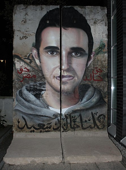
6title: Khaled Said Graffiti on Berlin Wall
artist: Nora Shalaby from Egypt
date: 2011-10-02 20:13
medium: technique Mural ar تقنيَّات مُختلفة لكن الغالب هو الطلاء المرشوش en Mixed technique but mostly spray paint de Mischtechnik hauptsächlich aber Sprühdosenlack
dimensions: size m 2.50 1.80
current location: ar|مركز [[w:Friedrich Ebert Foundation|مؤسسة فريدريش إيبرت]] الرئيسي، [[:ar:برلين|ببرلين]] en|The headquarters of the [[w:Friedrich Ebert Foundation|Friedrich Ebert Foundation]], [[w:Berlin|Berlin]] de|Hauptquartier der Friedrich Ebert Stiftung, Berlin
source: link
credit:
- Uploaded by The Egyptian Liberal
license:
CC BY 2.0
 7
7title: Piri Reis World Map in a Double Hemisphere - Google Art Project
artist: Piri Reis
date: late 11th century AH/AD 17th century-early 12th century AH/AD 18th century (Ottoman)
medium: en ink and pigments on laid European paper
dimensions: w24 x h34 cm
current location: The Walters Art Museum
credit: OQHqOPdmS55lkA at Google Cultural Institute maximum zoom level
license:Public domain
 8
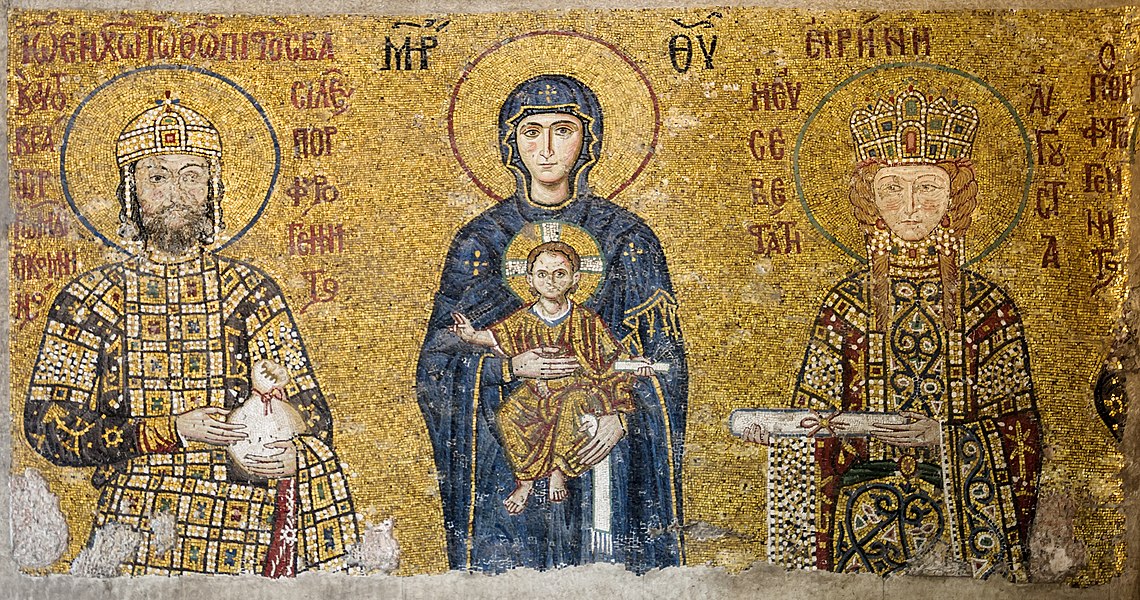
8title: Comnenus mosaics Hagia Sophia
artist:
Unknown authordate: circa 1118 AD
current location: institution|wikidata=Q12506
source: sf by u|Myrabella , date|2012|11|8
credit: Self-photographed by Myrabella,
license:Public domain
 9
9title: Medal, campaign (AM 799885 4)
artist:
Abdülmeciddate: (Pre 1977); Abdülmecid I (1839-1861)-Ottoman Empire; 1855; Crimean War; (1855)
dimensions: diameter: 36mm<br> width: 31mm<br> notes: medal<br> notes: ribbon
current location: Institution:Auckland War Memorial Museum
source: Images from Auckland Museum|section=humanhistory|object=object|id=799885 [link Photo]
credit: Photo
description: Turkish Crimea Medal, (British) 1854-56 Medal awarded to Leopold Miller, 1st Battalion I - Royals circular silver medal; ornamental scroll suspension; with ribbon obverse- map of Crimea spread over cannon wheel resting on Russian flag; to left are three cannon balls and a ramrod, to the right, an anchor and mortar; issuing from behind the cannon are the four flags of the allies; inscribed below CRIMEA 1855 reverse- enclosed within a wreath of laurel, the Sultan’s cypher, below in Turkish script ‘CRIMEA’ and the year in arabic 1271 A.H. (1855 AD) ribbon- waterred crimson with green edges named on edge- (LE)O. MILLER 1ST BATN. 1 - ROYALS
license:
CC BY 4.0

title: Print, map (BM 1895,0122.734)
artist: unknown
date: 1515
medium: paper
dimensions: : Height: 455 millimetres (including title) : Height: 430 millimetres (without title) : Width: 430 millimetres
current location: Institution:British Museum
source: link
credit: link
license:Public domain


