 1
1title: 1771 Bonne Map of Arabia Geographicus - Arabia-bonne-1771
artist: Rigobert Bonne
date: 1771 (dated)
dimensions: Size unit=in width=18.25 height=12.5
source: Lattre, Jean, <i>Atlas Moderne ou Collection de Cartes sur Toutes les Parties du Globe Terrestre</i>, c. 1775. Geographicus-source
credit: This file was provided to Wikimedia Commons by Geographicus Rare Antique Maps, a specialist dealer in rare maps and other cartography of the 15th, 16th, 17th, 18th and 19th centuries, as part of a cooperation project.
description: A beautiful example of Rigobert Bonne's 1771 decorative map of the arabian Peninsula. Covers from the Mediterranean to the Indian Ocean and from the Red Sea to the Persian Gulf. Includes the modern day nations of Saudi Arabia, Palestine, Jordan, Kuwait, Iraq, Yemen, Oman, the United Arab Emirates, and Bahrain. Names Mt. Sinai, Mecca and Jerusalem as well as countless other cities and desert oases. Also notes numerous offshore shoals, reefs, and other dangers in the Red Sea and the Persian Gulf. There is a large decorative title cartouche in the upper right hand quadrant. A fine map of the region. Drawn by R. Bonne in 1771 for issue as plate no. A 25 in Jean Lattre's 1776 issue of the Atlas Moderne .
license:Public domain
 2
2title: 1818 Pinkerton Map of Arabia and the Persian Gulf Geographicus - Arabia2-pinkerton-1818
artist: John Pinkerton
date: 1818 (undated)
dimensions: Size unit=in width=28 height=21
source: Pinkerton, J., <i>A Modern Atlas, from the Lates and Best Authorities, Exhibiting the Various Divisions of the World with its chief Empires, Kingdoms, and States; in Sixty Maps, carefully reduced from the Larges and Most Authentic Sources.</i> 1818, Philadelphia, Thomas Dobson Edition. Geographicus-source
credit: This file was provided to Wikimedia Commons by Geographicus Rare Antique Maps, a specialist dealer in rare maps and other cartography of the 15th, 16th, 17th, 18th and 19th centuries, as part of a cooperation project.
description: Extraordinary large format map of Arabia published in 1818 by cartographer John Pinkerton. Centered on the desert province of Neged, this map details the entire arabian peninsula as well as the Red Sea, the Persian Gulf, and adjacent parts of Africa and Persia. Covers the modern day countries of Saudi Arabia, Yemen, Oman, United Arab Emirates, Qatar and Kuwait. Pinkerton offers extraordinary detail throughout noting both physical and political details. When this map was made the interior of Arabia was little known in European circles. Most of the cartographic material used to compose this map comes from older sources and from the ill fated expedition of the Danish explorer Carsten Neibuhr. Neibuhr was the sole survivor of one of the few European expeditions to this region in the 18th century. His work had a profound influence on the cartography of this region for some 200 years. This is undoubtedly one the most attractive and influential maps of the arabian peninsula to appear in the 19th century. Drawn by L. Herbert and engraved by Samuel Neele under the direction of John Pinkerton. The map comes from the scarce American edition of Pinkerton’s Modern Atlas, published by Thomas Dobson & Co. of Philadelphia in 1818.
license:Public domain
 3
3title: 1866 Johnson Map of Arabia, Persia, Turkey and Afghanistan (Iraq) Geographicus - Arabia-johnson-1866
artist: Alvin Jewett Johnson
date: 1866 (undated)
dimensions: Size unit=in width=16.5 height=13
source: Johnson, A. J., <i>Johnson's New Illustrated Family Atlas of The World with Physical Geography, and with Descriptions Geographical, Statistical, and Historic including The Latest Federal Census, A Geographical Index, and a Chronological History of the Civil War in America</i>, 1866. Geographicus-source
credit: This file was provided to Wikimedia Commons by Geographicus Rare Antique Maps, a specialist dealer in rare maps and other cartography of the 15th, 16th, 17th, 18th and 19th centuries, as part of a cooperation project.
description: A very nice example of A. J. Johnson’s 1866 map of Arabia, Persia and Turkey in Asia. Covers from the Mediterranean and Egypt eastwards as far as the Mouths of the Indus River, as well as southward as far as the Horn of Africa and northwards to the Black Sea. Depicts most of the politically volatile modern day middle east, including the nations of Afghanistan, Iraq, Iran, Saudi Arabia, Jordan, Israel, Syria, Lebanon and Turkey. Offers color coding according to country and region as well as notations regarding desert caravan routes, oases, roadways, river systems, forts and monasteries, and some topographical features. Ostensibly this map is very similar to Colton's 1858 map of the same region, however, there are a number of significant differences. Johnson reduced Colton's original map in order to expand the map westward by about 10 degrees, making it possible for him to incorporate all of Turkey as well as add significant detail in northwestern Africa and the Nile Valley. Johnson's retooling of the map also allowed for the addition of his three attractive woodcut views: Muscat (lower left), Trebisond (lower left) and the Castle and Port of Smyrna (lower right). Features the fretwork style border common to Johnson’s atlas work from 1864 to 1869. Published by A. J. Johnson and Ward as plate number 95 in the 1865 edition of Johnson’s New Illustrated Family Atlas. This is the last edition of the Family Atlas to bear the Johnson and Ward imprint.
license:Public domain
 4
4title: Jacques Laurent Agasse - The Wellesley Grey Arabian Led through the Desert - Google Art Project
artist:
Jacques-Laurent Agasse (1767 - 1849) – Artist (Swiss, active in Britain (from 1800))
Born in Geneva. Dead in England.
Details of artist on Google Art Projectdate: circa 1810
dimensions: w1270 x h1019 cm
current location: en|Not on View Yale Center for British Art
credit: kwEB0jz_Qlz6Vg at Google Cultural Institute maximum zoom level
license:Public domain
 5
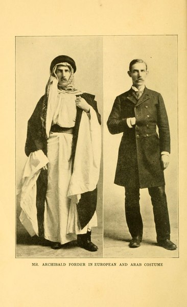
5title: ’Ventures among the Arabs in Desert, Tent, and Town: Thirteen Years of Pioneer Missionary Life with the Ishmaelites of Moab, Edom, and Arabia
artist: Forder, A. (Archibald), born 1863
date: 1905
medium: ru 1=Книги fr 1=Livres en 1=Books zh 1=图书 pt 1=Livros ar 1=كتب es 1=Libros
dimensions: en 1=292 pages : frontispiece, plates, portraits, folded map ; 21 centimeters
current location: ru|1=Библиотека Конгресса fr|1=Bibliothèque du Congrès en|1=Library of Congress zh|1=国会图书馆 pt|1=Biblioteca do Congresso ar|1=مكتبة الكونغرس es|1=Biblioteca del Congreso
description: Archibald Forder was an American missionary, born in 1863, who worked for 13 years in the Middle East, primarily in Al-Karak in Palestine, at that time part of the Ottoman Empire. ’Ventures among the Arabs is Forder’s account of his work and travels in the region. Chapter 12 contains a summary overview of Arabia, with brief treatments of the geography, principal cities, government structures, economy, population and language, religion, animals, and modes of transportation. Several chapters recount Forder’s largely unsuccessful attempts to enter Arabia for missionary work. Their titles convey the tone of the narrative, for example, “Attempts to enter Arabia end in Capture, Prison, and Broken Bones” and “At the Mercy of Murderers, Brigands, and Raging Seas.” In Chapter 23, “Customs Substantiating Scripture,” Forder describes the many similarities between contemporary Arab customs and practices mentioned in the Bible. In Chapter 24, “Arabia in its Relation to the Bible,” he discusses ancient Arabia as portrayed in the Bible.
arabian Peninsula; Bible. Old Testament; Description and travel; Missionarieslicense:Public domain
 6
6title: Central Asia: Afghanistan and Her Relation to British and Russian Territories
artist: unknown
date: 1885
medium: ru 1=Карты fr 1=Cartes en 1=Maps zh 1=地图 pt 1=Mapas ar 1=خرائط es 1=Mapas
dimensions: en 1=1 map : color ; 44 x 71 centimeters
current location: ru|1=Библиотека Конгресса fr|1=Bibliothèque du Congrès en|1=Library of Congress zh|1=国会图书馆 pt|1=Biblioteca do Congresso ar|1=مكتبة الكونغرس es|1=Biblioteca del Congreso
description: This 1885 map shows Asia from the eastern littoral of the Mediterranean to western China and the Indian subcontinent. An inset in the upper right depicts the region in the broader context of Asia, Europe, and Africa. A focal point of the map is Afghanistan, where, in what was called “the Great Game,” the Russian and British empires competed for influence throughout most of the 19th century. The British feared that the Russians, who annexed large parts of Central Asia in the 1860s and 1870s, would use Afghanistan as a base from which to threaten British India. The central region of Arabia is described as “uninterrupted desert from Mecca to Oman.” The map has two distance scales, one in English statute miles and another in Russian versts. Intended for American audiences, it also shows, at the bottom center, the U.S. states of Indiana and Ohio, which are drawn to scale as a way of comparing distances in the region with those in the United States. The map was issued by the G.W. & C.B. Colton Company, which was owned by George Woolworth Colton (1827–1901) and Charles B. Colton (1832–1916), the sons of Joseph Hutchins Colton (1800–93), founder of the pioneering map publishing firm J.H. Colton & Company.
arabian Gulf; arabian Peninsula; Balkan Peninsula; Himalaya Mountains; Persian Gulflicense:Public domain
 7
7title: Arabia: Comprising Its Geography, History, and Topography
artist: Conder, Josiah, 1789-1855
date: 1833
medium: ru 1=Рукописи fr 1=Manuscrits en 1=Manuscripts zh 1=手稿 pt 1=Manuscritos ar 1=مخطوطات es 1=Manuscritos
dimensions: en 1=340 pages
current location: ru|1=Библиотека Конгресса fr|1=Bibliothèque du Congrès en|1=Library of Congress zh|1=国会图书馆 pt|1=Biblioteca do Congresso ar|1=مكتبة الكونغرس es|1=Biblioteca del Congreso
description: Josiah Conder (1789–1855) was a British publisher and author who wrote or compiled 33 volumes of travel literature about nearly every region of the world, including the Middle East. Conder himself never traveled abroad and composed his works by drawing upon the writings of earlier scholars and explorers. As indicated in the subtitle, Conder organized his book on Arabia into sections. He begins by describing the topography of the different regions of Arabia and such climatic phenomena as the semoum (poison) winds that blow across the Syrian desert in the summer. He follows with a long discussion of arabian history, from the ancient pre-Islamic Himyarite Kingdom in Yemen (circa 110 BC–525 AD) to the rise of the Prophet Muhammad in the early seventh century, and only briefly discusses contemporary political events. The historical section of the work draws heavily on The History of the Decline and Fall of the Roman Empire by Edward Gibbon (1737–94) and the translation of the Qur'an into English by George Sale (circa 1697–1736).
arabian Peninsula; Bible. Old Testament; Description and travel; Holy Roman Empire; Islam; Muḥammad, Prophet, died 632license:Public domain
 8
8title: Charles-Philogène Tschaggeny - An Arabian in the desert
artist: Charles Tschaggeny
date: 1858
medium: Technique oil panel
dimensions: Size cm height=43.5 width=60
source: link
credit: link
description: An arabian in the desert
license:Public domain
 9
9title: Arabe du désert (BM 1865,1209.754)
artist:
Print made by: Antoine Jean Gros (Baron Gros)
- Printed by: Charles Philibert du Saillant, Comte de Lasteyrie
date: 1817
medium: paper
dimensions: : Height: 185 millimetres : Width: 258 millimetres
current location: Institution:British Museum
source: link
credit: link
description: arabian warrior, sitting next to his horse and holding out a cup of water to a man approaching from the right. 1817
Lithographlicense:Public domain

title: Arabe du désert (BM 1876,0510.312)
artist:
Print made by: Antoine Jean Gros (Baron Gros)
- Printed by: Charles Philibert du Saillant, Comte de Lasteyrie
date: 1817
medium: paper
dimensions: : Height: 185 millimetres : Width: 258 millimetres
current location: Institution:British Museum
source: link
credit: link
description: arabian warrior, sitting next to his horse and holding out a cup of water to a man approaching from the right. 1817
Lithographlicense:Public domain


