 1
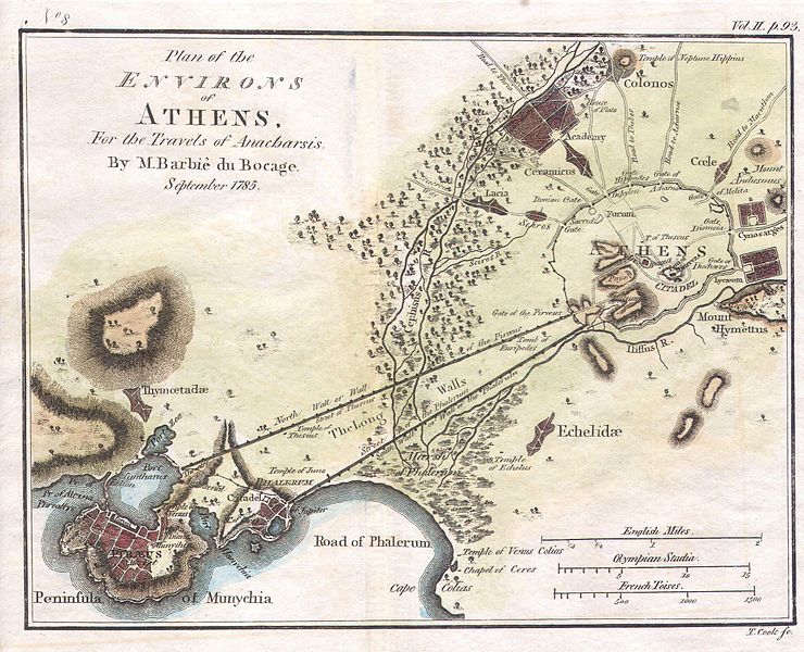
1title: 1784 Bocage Map of the City of Athens in Ancient Greece Geographicus - AthensPlan2-white-1793
artist: Jean-Denis Barbié du Bocage
date: 1784
dimensions: Size unit=in width=13 height=9
source: Geographicus-source
credit: This file was provided to Wikimedia Commons by Geographicus Rare Antique Maps, a specialist dealer in rare maps and other cartography of the 15th, 16th, 17th, 18th and 19th centuries, as part of a cooperation project.
description: This lovely little map or city plan of Athens in ancient Greece, was prepared by M. Barbie de Bocage in 1784 for the “Travels of Anarcharsis”. Athens, capital of the Athenian Empire, was the heart of ancient Greek culture and the quintessential ancient Greek city state. This plan of Athens, based on excavations and ancient sources offers impressive and accurate detail.
license:Public domain
 2
2title: 1786 Bocage Map of Corinthia, Sicyonia and Achaia in Ancient Greece Geographicus - Achaia-white-1793
artist: Jean-Denis Barbié du Bocage
date: 1786
dimensions: Size unit=in width=13 height=6
source: Geographicus-source
credit: This file was provided to Wikimedia Commons by Geographicus Rare Antique Maps, a specialist dealer in rare maps and other cartography of the 15th, 16th, 17th, 18th and 19th centuries, as part of a cooperation project.
description: This lovely little map of Corinthia, Sicyonia and Achaia, in northern Peloponnesus of ancient Greece, was prepared by M. Barbie de Bocage in 1786 for the “Travels of Anarcharsis”. Taken from the early D’Anville map.
license:Public domain
 3
3title: 1786 Bocage Map of Messenia in Ancient Greece Geographicus - Messemoa-white-1793
artist: Jean-Denis Barbié du Bocage
date: 1786
dimensions: Size unit=in width=9 height=8
source: Geographicus-source
credit: This file was provided to Wikimedia Commons by Geographicus Rare Antique Maps, a specialist dealer in rare maps and other cartography of the 15th, 16th, 17th, 18th and 19th centuries, as part of a cooperation project.
description: This lovely little map of Messenia, in the southeast of ancient Greece, was prepared by M. Barbie de Bocage in 1786 for the “Travels of Anarcharsis”. Follows the earlier D’ Anville map. This peninsula and gulf just south of Arcadia and west of Laconia, was generally dominated by Sparta, its more powerful neighbor to the east.
license:Public domain
 4
4title: 1788 Bocage Map of Thessaly in Ancient Greece ( the home of Achilles) Geographicus - Thessaly-white-1793
artist: Jean-Denis Barbié du Bocage
date: 1788
dimensions: Size unit=in width=12 height=8
source: Geographicus-source
credit: This file was provided to Wikimedia Commons by Geographicus Rare Antique Maps, a specialist dealer in rare maps and other cartography of the 15th, 16th, 17th, 18th and 19th centuries, as part of a cooperation project.
description: This lovely little map of Thessaly, just south of Macedonia in ancient Greece, was prepared by M. Barbie de Bocage in 1786 for the “Travels of Anarcharsis”. Taken from the early D’Anville map. Thessaly is the legendary seat of Phthiotis, home of Achilles and his Myrmidons, who were so prominently featured in the Illiad. Achilles’s father King Peleus, ruled this region. There is also a curious theory that the people of Thessaly were blond, drawn from Homer’s reference to Achillies.
license:Public domain
 5
5title: 1837 Malte Brun Map of Ancient Egypt, Nubia ( Sudan ) and Abyssinia ( Ethiopia ) - Geographicus - EgyptAncient-mb-1837
artist: link
date: 1837
dimensions: Size unit=in width=12 height=9
source: Geographicus-source
credit: This file was provided to Wikimedia Commons by Geographicus Rare Antique Maps, a specialist dealer in rare maps and other cartography of the 15th, 16th, 17th, 18th and 19th centuries, as part of a cooperation project.
description: This is a beautiful 1837 copperplate lithograph map of ancient Egypt, Nubia and Abyssina. These roughly corresponds to the modern day nations of Egypt, Sudan and Ethiopia. Includes the ancient nations of Upper Egypt, Lower Egypt, Heptanomis, Arabia, and Judea, and Petra. Topographical details abound. All text is in French or Latin.
license:Public domain
 6
6title: 1837 Malte Brun Map of Turkey or Asia Minor in Ancient Times - Geographicus - TurkeyAncient-mb-1837
artist: link
date: 1837
dimensions: Size unit=in width=12 height=9
source: Geographicus-source
credit: This file was provided to Wikimedia Commons by Geographicus Rare Antique Maps, a specialist dealer in rare maps and other cartography of the 15th, 16th, 17th, 18th and 19th centuries, as part of a cooperation project.
description: This is a beautiful 1837 hand colored map depicts Asia Minor or what is today Turkey as it appeared in ancient time. This region saw the development of currency, the conquest of Troy, as well as the construction of three of the ancient World’s Wonders seven Wonders. All text is in French.
license:Public domain
 7
7title: 1794 Anville Map of Ancient Greece Geographicus - GreeceAncient-anville-1794
artist: Jean Baptiste Bourguignon d'Anville
date: 1794 (dated)
dimensions: Size unit=in width=19.5 height=20.5
source: D'Anville, J. B. B., Complete Body of ancient Geography, Laurie and Whittle, London, 1795. Geographicus-source
credit: This file was provided to Wikimedia Commons by Geographicus Rare Antique Maps, a specialist dealer in rare maps and other cartography of the 15th, 16th, 17th, 18th and 19th centuries, as part of a cooperation project.
description: A large and dramatic J. B. B. D'Anville map of ancient Greece. Covers from Macedonia to the Peloponnesus, inclusive of Euboea and the Ionian Isles. Details mountains, rivers, cities, roadways, and lakes with political divisions highlighted in outline color. Decorative title cartouche in the lower left quadrant depicts an ancient Greek woman lounging against a Tuscan column while two cherubic children create art. Includes five distance scales, bottom left, referencing various measurement systems common in antiquity. Text in Latin and English. Drawn by J. B. B. D'Anville in 1762 and published in 1794 by Laurie and Whittle, London.
license:Public domain
 8
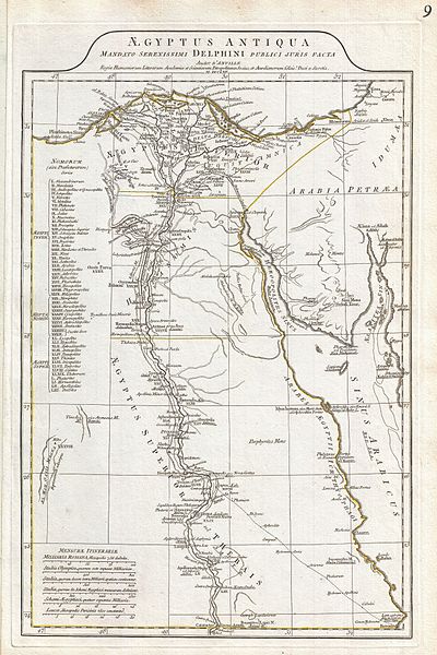
8title: 1794 Anville Map of Ancient Egypt Geographicus - Egypt-anville-1794
artist: Jean Baptiste Bourguignon d'Anville
date: 1794 (dated)
dimensions: Size unit=in width=12.5 height=20
source: D'Anville, J. B. B., Complete Body of ancient Geography, Laurie and Whittle, London, 1795. Geographicus-source
credit: This file was provided to Wikimedia Commons by Geographicus Rare Antique Maps, a specialist dealer in rare maps and other cartography of the 15th, 16th, 17th, 18th and 19th centuries, as part of a cooperation project.
description: A large and dramatic 1794 J. B. B. D'Anville map of ancient Egypt Covers from the Nile Delta and Gaza south as far as Aswan. Details mountains, rivers, cities, roadways, and lakes with political divisions highlighted in outline color. Features both ancient and contemporary place names, ie. Thebae and Luxor, for each destination - an invaluable resource or scholars of antiquity. Identifies the Pyramids, Mount Sinai, Natron, Philae Island, the Cataracts, etc. Title area appears in a raised zone above the map proper. Includes six distance scales, bottom left, referencing various measurement systems common in antiquity. Text in Latin and English. Drawn by J. B. B. D'Anville in 1762 and published in 1794 by Laurie and Whittle, London.
license:Public domain
 9
9title: 1650 Jansson Map of the Ancient World Geographicus - OrbisTerrarum-jansson-1650
artist: Jan Janssonius
date: 1650 (undated)
dimensions: Size unit=in width=20.5 height=16.5
source: Jansson, J., <i>Atlantis majoris quinta pars, orbem maritimum seu omnium marium orbis terrarium…</i>, part 2, c. 1650. Geographicus-source
credit: This file was provided to Wikimedia Commons by Geographicus Rare Antique Maps, a specialist dealer in rare maps and other cartography of the 15th, 16th, 17th, 18th and 19th centuries, as part of a cooperation project.
description: An exceptional 1650 map of the world as it was known to the ancients by Jan Janssonius. Such maps, which filled in contemporary geography with ancient place names, were popular in the post-Renaissance period. Scholars digging through rediscovered Greek and Roman texts needed a geographical reference point for the numerous place names that peppered these works. Such maps began appearing in 16t century. This particular example is a significant reworking of an earlier chart by A. Ortelius. It covers Europe, western Asia, and Northern Africa as well as significant, though blank, portions of the surrounding seas. Jansson has curiously oriented this chart with Africa at the center. As such Europe and Asia seem to take on an almost peripheral role. Countless ancient world place names, most of which are drawn from Ptolemy's Geographica , are included. Jansson also notes all five climatic zones, the frigid zones in the north and south, the habitable temperate zones to the north and south of the tropics, and the inhospitable torrid zone to either side of the Equator. Cartographically this map does not stray too far from the standard model of the period. In Africa the Mountains of the Mood as well as the Likes of the Nile are identified. The Caspian Sea is incorrectly oriented on a east-west axis. Sri Lanka is identified with Tapobrana. In Southeast Asia, the five great rivers of the region are shown to originate from the apocryphal lake known, though not labeled here, as Chaimay. Various fishing, sailing, and merchant ships, as well as the odd sea monster, fill the unknown seas. This example represents the second state of this map with a fully developed dedication at bottom center. The first state of the chart left this area blank. A baroque title area complete with cherubs occupies the upper part of the plate. This chart was published in part 2 of Jansonnius' 1650 Atlas Maritimus or volume 5 in his Atlantis Majoris .
license:Public domain

title: Map of Ancient Arabia
artist: Weigel, Christoph (1654-1725)
date: 1720
medium: ru 1=Карты fr 1=Cartes en 1=Maps zh 1=地图 pt 1=Mapas ar 1=خرائط es 1=Mapas
dimensions: en 1=1 map; color; 35.90 x 29.30 centimeters
current location: ru|1=Национальная библиотека Катара fr|1=Bibliothèque nationale du Qatar en|1=Qatar National Library zh|1=卡塔尔国家图书馆 pt|1=Biblioteca Nacional do Catar ar|1=مكتبة قطر الوطنية es|1=Biblioteca Nacional de Catar
description: This map of the Arabian Peninsula, published in 1720, shows Arabia Felix, Arabia Deserta, and Arabia Petraea. Other regions included are Palestine, Mesopotamia, Chaldea, Persia, Aegyptus, and Aethiopia. A large number of towns are shown. The title cartouche includes nine vignette coins. The tribal and town names on the map are those used by Ptolemy. Some are used more than once, with variations. Thus “Indicara,” “Iacara,” “Ichara,” and “Aphana” all could indicate the same place: the spot where Alexander the Great intended to build a capital on an island in the Arabian Gulf, enabling him to control the trade of the region and extend his empire (a scheme that he was unable to accomplish before he died). Archeological research suggests that this place was Failakah Island in present-day Kuwait, although some historians place it at Abu Ali Island. The map shows a peninsula near present-day Bahrain. The islands of “Arathos” and “Thylaso” indicate Muharraq and Bahrain islands, respectively, which are actually located north of Qatar. On this map, they are placed on the Persian coast side, probably because the cartographer confused them with “Hormuz” and “Qishm.” Qatar is mentioned on the map as “Catara,” but its shape and location are not accurate. The map is by Christoph Weigel, a German engraver, art dealer, and publisher.
Arabian Gulf; Arabian Peninsula; Persian Gulflicense:Public domain


