 MENU
MENU



 1
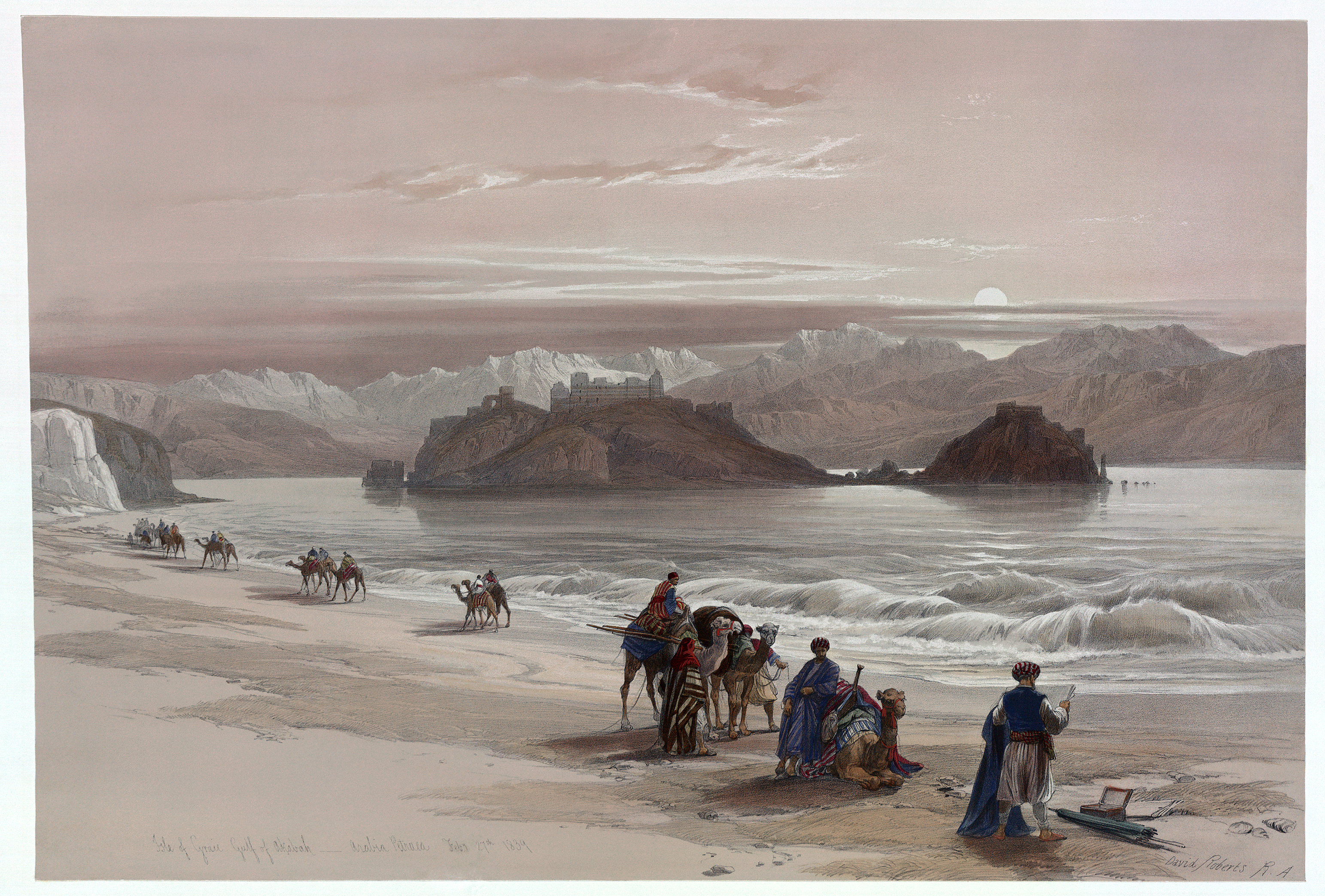
1title: Isle of Graia3
artist: <bdi><a href="https://en.wikipedia.org/wiki/en:David_Roberts_(painter)" class="extiw" title="w:en:David Roberts (painter)"><span title="Scottish painter (1796-1864)">David Roberts</span></a> </bdi>
date: 27 February 1839<div style="display: none;">date QS:P571,+1839-02-27T00:00:00Z/11</div>
source: Illus. in: The Holy Land, Syria, Idumea, Arabia, Egypt and Nubia / from drawings made on the spot by David Roberts ... ; lithographed by Louis Haghe. London : F.G. Moon, 1842-1845, v. 3, pts. 16-18, p. 8. Library of Congress, Reproduction number LC-USZC4-3525 LOC-image|id=ppmsca.08343 Retouched picture|Dirt and smudges removed. Banding corrected. Histogram adjusted and colors balanced, with localized adjustments to brightness and color balance.|editor=GerardM|orig=Isle of Graia.tif Modifications made by [[User:Durova|Durova]]
credit: This image is available from the United States <a href="//commons.wikimedia.org/wiki/Library_of_Congress" title="Library of Congress">Library of Congress</a>'s <a rel="nofollow" class="external text" href="//www.loc.gov/rr/print/">Prints and Photographs division</a><br> under the digital ID <a rel="nofollow" class="external text" href="http://hdl.loc.gov/loc.pnp/ppmsca.08343">ppmsca.08343</a>.<br><small>This tag does not indicate the copyright status of the attached work. A normal copyright tag is still required. See <a href="//commons.wikimedia.org/wiki/Commons:Licensing" title="Commons:Licensing">Commons:Licensing</a> for more information.</small>
license:Public domain
 2
2title: <div class="fn"> Carte de Perse, dressee pour l'usage du Roy. Par G. Delisle premier Geographe de S.M. de l'Academie Royale des Sciences.</div>
artist: <bdi><a href="https://en.wikipedia.org/wiki/en:Guillaume_Delisle" class="extiw" title="w:en:Guillaume Delisle"><span title="French cartographer">Guillaume Delisle</span></a> </bdi>
date: 1724 (undated)
dimensions: Size unit=in width=25 height=20
source: De L'Isle, G., <i>Atlas de Geographie</i>, c. 1730. Geographicus-source
credit: This file was provided to Wikimedia Commons by <a rel="nofollow" class="external text" href="http://www.geographicus.com/">Geographicus Rare Antique Maps</a>, a specialist dealer in rare maps and other cartography of the 15th, 16th, 17th, 18th and 19th centuries, as part of a <a href="//commons.wikimedia.org/wiki/Commons:Geographicus" title="Commons:Geographicus">cooperation project</a>.
description: A fine first edition example of Guillaume De L’Isle’s important 1724 map of Persia. Covers from the Crimea and the Sea of Azov south to the Persian Gulf and the Straight of Ormuz and east as far as Kashmir (Cachmir) and Kabul (Caboul). This map includes modern day Iran, Iraq, Afghanistan, Kuwait, Uzbekistan, Turkmenistan, Tajikistan, Georgia, Armenia, and Azerbaijan, with adjacent parts of Russia, Pakistan, Turkey, Ukraine, and Kazakhstan, and Arabia. Cartographically De L’Isle’s mapping of Persia marks a significant advance in European cartographic knowledge of the region. This map benefits considerably from Russian cartographic surveys and other sources no doubt smuggled to Guillaume De L’Isle by his brother Nicholas de L’Isle, who held a cartographic position with the Russian Academy of Sciences. The extent to which Russian data influenced this map is nowhere more evident than in De L’Isle’s remarkable rendering of the Caspian Sea – one of the first accurate maps of the great lake to follow Van Verden’s historic survey of 1721. Russian cartographic information is also apparent with regard to place names, such as the Russian name for the Aral Sea (Glouchoiye). It is equally likely that De L’Isle drew on Russian sources for his mapping of the Silk Route centers of Bukhara, Samarkand, and Ferghana, which were known stopping points for Russian <u style="background-color:yellow;" class="">trade</u> envoys to China. For the remainder of Persia De L’Isle most likely updated Persian and <u style="background-color:yellow;" class="">arabic</u> cartographic information with reports from Georgian and Armenian traders and mercenaries active throughout Persia. It may be through these sources that De L’Isle was able to add considerable geographic information regarding <u style="background-color:yellow;" class="">trade</u> routes and place names in central Persia. These include such significant advances as the identification of Terheran (Tiheran), the current capital of Iran, which is notable absent it earlier European maps of Persia. This map was drawn by Guillaume De L’Isle and engraved by P. Starckman. It issued independently as well as included in a number of composite atlases including De L’Isle’s 1731 Atlas de Geographie . A number of reissues by Buache, Covens & Mortier, and others followed.
license:Public domain
 3
3title: Carte de Perse, dressee pour l'usage du Roy. Par G. Delisle premier Geographe de S.M. de l'Academie Royale des Sciences.
artist: <bdi><a href="https://en.wikipedia.org/wiki/en:Guillaume_Delisle" class="extiw" title="w:en:Guillaume Delisle"><span title="French cartographer">Guillaume Delisle</span></a> </bdi>
date: 1724 (undated)
dimensions: Size unit=in width=25 height=20
source: Extracted from|Image:1724 De L'Isle Map of Persia (Iran, Iraq, Afghanistan) - Geographicus - Persia-delisle-1724.jpg * Original source: De L'Isle, G., <i>Atlas de Geographie</i>, c. 1730. Geographicus-source
credit: This file was provided to Wikimedia Commons by <a rel="nofollow" class="external text" href="http://www.geographicus.com/">Geographicus Rare Antique Maps</a>, a specialist dealer in rare maps and other cartography of the 15th, 16th, 17th, 18th and 19th centuries, as part of a <a href="//commons.wikimedia.org/wiki/Commons:Geographicus" title="Commons:Geographicus">cooperation project</a>.
description: A fine first edition example of Guillaume De L’Isle’s important 1724 map of Persia. Covers from the Crimea and the Sea of Azov south to the Persian Gulf and the Straight of Ormuz and east as far as Kashmir (Cachmir) and Kabul (Caboul). This map includes modern day Iran, Iraq, Afghanistan, Kuwait, Uzbekistan, Turkmenistan, Tajikistan, Georgia, Armenia, and Azerbaijan, with adjacent parts of Russia, Pakistan, Turkey, Ukraine, and Kazakhstan, and Arabia. Cartographically De L’Isle’s mapping of Persia marks a significant advance in European cartographic knowledge of the region. This map benefits considerably from Russian cartographic surveys and other sources no doubt smuggled to Guillaume De L’Isle by his brother Nicholas de L’Isle, who held a cartographic position with the Russian Academy of Sciences. The extent to which Russian data influenced this map is nowhere more evident than in De L’Isle’s remarkable rendering of the Caspian Sea – one of the first accurate maps of the great lake to follow Van Verden’s historic survey of 1721. Russian cartographic information is also apparent with regard to place names, such as the Russian name for the Aral Sea (Glouchoiye). It is equally likely that De L’Isle drew on Russian sources for his mapping of the Silk Route centers of Bukhara, Samarkand, and Ferghana, which were known stopping points for Russian <u style="background-color:yellow;" class="">trade</u> envoys to China. For the remainder of Persia De L’Isle most likely updated Persian and <u style="background-color:yellow;" class="">arabic</u> cartographic information with reports from Georgian and Armenian traders and mercenaries active throughout Persia. It may be through these sources that De L’Isle was able to add considerable geographic information regarding <u style="background-color:yellow;" class="">trade</u> routes and place names in central Persia. These include such significant advances as the identification of Terheran (Tiheran), the current capital of Iran, which is notable absent it earlier European maps of Persia. This map was drawn by Guillaume De L’Isle and engraved by P. Starckman. It issued independently as well as included in a number of composite atlases including De L’Isle’s 1731 Atlas de Geographie . A number of reissues by Buache, Covens & Mortier, and others followed.
license:Public domain
 4
4title: Explanation of the Work of al-Ghazali and Nuh ibn al-Tahir al-Fulani
artist: Sulaymān ibn Aḥmad
date: 1800<div style="display: none;">date QS:P571,+1800-00-00T00:00:00Z/9</div>
medium: ru 1=Рукописи fr 1=Manuscrits en 1=Manuscripts zh 1=手稿 pt 1=Manuscritos ar 1=مخطوطات es 1=Manuscritos
current location: ru|1=Мемориальная библиотека Мамма Хайдара fr|1=Bibliothèque commémorative Mamma Haidara en|1=Mamma Haidara Commemorative Library zh|1=海达拉家族纪念图书馆 pt|1=Biblioteca Comemorativa Mamma Haidara ar|1=مكتبة ماما حيدرة التذكارية es|1=Colección Conmemorativa Mamma Haidara
source: http://www.wdl.org/media/467/service/thumbnail/6000x6000/1/1.jpg * Gallery: http://www.wdl.org/en/item/467/
credit: <p><a rel="nofollow" class="external free" href="http://www.wdl.org/media/467/service/thumbnail/6000x6000/1/1.jpg">http://www.wdl.org/media/467/service/thumbnail/6000x6000/1/1.jpg</a> </p> <ul><li>Gallery: <a rel="nofollow" class="external free" href="http://www.wdl.org/en/item/467/">http://www.wdl.org/en/item/467/</a> </li></ul>
description: Timbuktu, founded around 1100 as a commercial center for <u style="background-color:yellow;" class="">trade</u> across the Sahara Desert, was also an important seat of Islamic learning from the 14th century onward. The libraries of Timbuktu contain many important manuscripts, in different styles of <u style="background-color:yellow;" class="">arabic</u> scripts, which were written and copied by Timbuktu’s scribes and scholars. These works constitute the city’s most famous and long-lasting contribution to Islamic and world civilization. This work by Sulayman ibn Ahmad comments on the work of the famous scholar al-Ghazali and discusses a commentary on Ghazali's work by Nuh ibn al-Tahir al-Fulani, a well-known scholar from Timbuktu. <br><u style="background-color:yellow;" class="">arabic</u> manuscripts; Astrology; Astronomy; Ghazzālī, 1058-1111; Islamic manuscripts; Nūḥ ibn al-Ṭāhir al-Fūlānī; Sufism
license:Public domain
 5
5title: Poem
artist: al-Mukhtār ibn Aḥmad ibn Abī Bakr al-Kuntī al-Kabīr, Sayyid
date: between 1500 and 1900 <div style="display: none;">date QS:P571,+1500-00-00T00:00:00Z/6,P1319,+1500-00-00T00:00:00Z/9,P1326,+1900-00-00T00:00:00Z/9</div>
medium: ru 1=Рукописи fr 1=Manuscrits en 1=Manuscripts zh 1=手稿 pt 1=Manuscritos ar 1=مخطوطات es 1=Manuscritos
current location: ru|1=Мемориальная библиотека Мамма Хайдара fr|1=Bibliothèque commémorative Mamma Haidara en|1=Mamma Haidara Commemorative Library zh|1=海达拉家族纪念图书馆 pt|1=Biblioteca Comemorativa Mamma Haidara ar|1=مكتبة ماما حيدرة التذكارية es|1=Colección Conmemorativa Mamma Haidara
source: http://dl.wdl.org/9658/service/9658.pdf * Gallery: http://www.wdl.org/en/item/9658/
credit: <p><a rel="nofollow" class="external free" href="http://dl.wdl.org/9658/service/9658.pdf">http://dl.wdl.org/9658/service/9658.pdf</a> </p> <ul><li>Gallery: <a rel="nofollow" class="external free" href="http://www.wdl.org/en/item/9658/">http://www.wdl.org/en/item/9658/</a> </li></ul>
description: Timbuktu (present-day Tombouctou in Mali), founded around 1100 as a commercial center for <u style="background-color:yellow;" class="">trade</u> across the Sahara Desert, was also an important seat of Islamic learning from the 14th century onward. The libraries there contain many important manuscripts, in different styles of <u style="background-color:yellow;" class="">arabic</u> scripts, which were written and copied by Timbuktu’s scribes and scholars. These works constitute the city’s most famous and long-lasting contribution to Islamic and world civilization. In <em>Qasīdah </em>(Poem), Sayyid al-Mukhtār ibn Aḥmad ibn Abī Bakr al-Kuntī al-Kabīr instructs students of Islamic law about the rights of orphans and of married women. He uses verse as a memory aid for the students. <br><u style="background-color:yellow;" class="">arabic</u> calligraphy; <u style="background-color:yellow;" class="">arabic</u> manuscripts; <u style="background-color:yellow;" class="">arabic</u> poetry; Children; Islamic law; Islamic manuscripts; Poetry; Timbuktu manuscripts; Women
license:Public domain
 6
6title: Commentary on the Work “Examples of Legal Hypotheses”
artist: Tumbukti, al-Qadi Muhammad ibn al-Imam Uthman al-Wakari
date: between 1500 and 1900 <div style="display: none;">date QS:P571,+1500-00-00T00:00:00Z/6,P1319,+1500-00-00T00:00:00Z/9,P1326,+1900-00-00T00:00:00Z/9</div>
medium: ru 1=Рукописи fr 1=Manuscrits en 1=Manuscripts zh 1=手稿 pt 1=Manuscritos ar 1=مخطوطات es 1=Manuscritos
current location: ru|1=Мемориальная библиотека Мамма Хайдара fr|1=Bibliothèque commémorative Mamma Haidara en|1=Mamma Haidara Commemorative Library zh|1=海达拉家族纪念图书馆 pt|1=Biblioteca Comemorativa Mamma Haidara ar|1=مكتبة ماما حيدرة التذكارية es|1=Colección Conmemorativa Mamma Haidara
source: http://dl.wdl.org/9659/service/9659.pdf * Gallery: http://www.wdl.org/en/item/9659/
credit: <p><a rel="nofollow" class="external free" href="http://dl.wdl.org/9659/service/9659.pdf">http://dl.wdl.org/9659/service/9659.pdf</a> </p> <ul><li>Gallery: <a rel="nofollow" class="external free" href="http://www.wdl.org/en/item/9659/">http://www.wdl.org/en/item/9659/</a> </li></ul>
description: Timbuktu (present-day Tombouctou in Mali), founded around 1100 as a commercial center for <u style="background-color:yellow;" class="">trade</u> across the Sahara Desert, was also an important seat of Islamic learning from the 14th century onward. The libraries there contain many important manuscripts, in different styles of <u style="background-color:yellow;" class="">arabic</u> scripts, which were written and copied by Timbuktu’s scribes and scholars. These works constitute the city’s most famous and long-lasting contribution to Islamic and world civilization. Islamic inheritance law is a highly regulated system in which individuals receive legacies depending upon their degree of relationship to the deceased. This work explains that system and elaborates upon its basis in the Qur’an. <br><u style="background-color:yellow;" class="">arabic</u> calligraphy; <u style="background-color:yellow;" class="">arabic</u> manuscripts; Inheritance and succession; Islamic law; Islamic manuscripts; Timbuktu manuscripts
license:Public domain
 7
7title: The Rewards of the Enlightened for their Defense of the Status of God’s Chosen Saints
artist: al-Mukhtār ibn Aḥmad ibn Abī Bakr al-Kuntī al-Kabīr, Sayyid
date: 1858<div style="display: none;">date QS:P571,+1858-00-00T00:00:00Z/9</div>
medium: ru 1=Рукописи fr 1=Manuscrits en 1=Manuscripts zh 1=手稿 pt 1=Manuscritos ar 1=مخطوطات es 1=Manuscritos
current location: ru|1=Мемориальная библиотека Мамма Хайдара fr|1=Bibliothèque commémorative Mamma Haidara en|1=Mamma Haidara Commemorative Library zh|1=海达拉家族纪念图书馆 pt|1=Biblioteca Comemorativa Mamma Haidara ar|1=مكتبة ماما حيدرة التذكارية es|1=Colección Conmemorativa Mamma Haidara
source: http://dl.wdl.org/9663/service/9663.pdf * Gallery: http://www.wdl.org/en/item/9663/
credit: <p><a rel="nofollow" class="external free" href="http://dl.wdl.org/9663/service/9663.pdf">http://dl.wdl.org/9663/service/9663.pdf</a> </p> <ul><li>Gallery: <a rel="nofollow" class="external free" href="http://www.wdl.org/en/item/9663/">http://www.wdl.org/en/item/9663/</a> </li></ul>
description: Timbuktu (present-day Tombouctou in Mali), founded around 1100 as a commercial center for <u style="background-color:yellow;" class="">trade</u> across the Sahara Desert, was also an important seat of Islamic learning from the 14th century onward. The libraries there contain many important manuscripts, in different styles of <u style="background-color:yellow;" class="">arabic</u> scripts, which were written and copied by Timbuktu’s scribes and scholars. These works constitute the city’s most famous and long-lasting contribution to Islamic and world civilization. This text explains the basic principles of Sufism, pointing out the various stages of knowledge that Sufi mystics pass through as their knowledge of God increases through their strict application of devotional discipline. Al-Mukhtār ibn Aḥmad ibn Abī Bakr al-Kuntī al-Kabīr, who died in 1811, further discusses the relationship between belief, Sufi doctrine, and knowledge of God. <br><u style="background-color:yellow;" class="">arabic</u> calligraphy; <u style="background-color:yellow;" class="">arabic</u> manuscripts; Islam -- Doctrines; Islamic manuscripts; Sufism; Timbuktu manuscripts
license:Public domain
 8
8title: The Response of Ahmad al-Bakayi to the Letter of Amir Ahmad, Ruler of Massinah
artist: Bākī ibn Sayyid Muḥammad ibn Sayyid al-Mukhtār al-Kuntī, Aḥmad
date: between 1853 and 1854 <div style="display: none;">date QS:P571,+1853-00-00T00:00:00Z/8,P1319,+1853-00-00T00:00:00Z/9,P1326,+1854-00-00T00:00:00Z/9</div>
medium: ru 1=Рукописи fr 1=Manuscrits en 1=Manuscripts zh 1=手稿 pt 1=Manuscritos ar 1=مخطوطات es 1=Manuscritos
current location: ru|1=Мемориальная библиотека Мамма Хайдара fr|1=Bibliothèque commémorative Mamma Haidara en|1=Mamma Haidara Commemorative Library zh|1=海达拉家族纪念图书馆 pt|1=Biblioteca Comemorativa Mamma Haidara ar|1=مكتبة ماما حيدرة التذكارية es|1=Colección Conmemorativa Mamma Haidara
source: http://dl.wdl.org/9668/service/9668.pdf * Gallery: http://www.wdl.org/en/item/9668/
credit: <p><a rel="nofollow" class="external free" href="http://dl.wdl.org/9668/service/9668.pdf">http://dl.wdl.org/9668/service/9668.pdf</a> </p> <ul><li>Gallery: <a rel="nofollow" class="external free" href="http://www.wdl.org/en/item/9668/">http://www.wdl.org/en/item/9668/</a> </li></ul>
description: Timbuktu (present-day Tombouctou in Mali), founded around 1100 as a commercial center for <u style="background-color:yellow;" class="">trade</u> across the Sahara Desert, was also an important seat of Islamic learning from the 14th century onward. The libraries there contain many important manuscripts, in different styles of <u style="background-color:yellow;" class="">arabic</u> scripts, which were written and copied by Timbuktu’s scribes and scholars. These works constitute the city’s most famous and long-lasting contribution to Islamic and world civilization. This document is a reply to the ruler of Massinah (present-day Macina), Amir Ahmad, who ordered the arrest of the noted German explorer Heinrich Barth (1821–65), who was suspected of spying for the British. There are two copies of the work: a shorter version, and a longer version, which incorporates information not given in the shorter. Shown here is the longer version. The author of the reply cites Islamic law in arguing that the arrest is illegal and declines to obey the amir. The scholar states that a non-Muslim entering the domain of Muslims in peace is protected and may not be arrested, have his property confiscated, or to be otherwise hindered. <br><u style="background-color:yellow;" class="">arabic</u> calligraphy; <u style="background-color:yellow;" class="">arabic</u> manuscripts; Barth, Heinrich, 1821-1865; Islamic law; Islamic manuscripts; Timbuktu manuscripts
license:Public domain
 9
9title: Commercial Agreement (Slave Trade)
artist: unknown
date: between 1500 and 1900 <div style="display: none;">date QS:P571,+1500-00-00T00:00:00Z/6,P1319,+1500-00-00T00:00:00Z/9,P1326,+1900-00-00T00:00:00Z/9</div>
medium: ru 1=Рукописи fr 1=Manuscrits en 1=Manuscripts zh 1=手稿 pt 1=Manuscritos ar 1=مخطوطات es 1=Manuscritos
current location: ru|1=Мемориальная библиотека Мамма Хайдара fr|1=Bibliothèque commémorative Mamma Haidara en|1=Mamma Haidara Commemorative Library zh|1=海达拉家族纪念图书馆 pt|1=Biblioteca Comemorativa Mamma Haidara ar|1=مكتبة ماما حيدرة التذكارية es|1=Colección Conmemorativa Mamma Haidara
source: http://dl.wdl.org/9670/service/9670.pdf * Gallery: http://www.wdl.org/en/item/9670/
credit: <p><a rel="nofollow" class="external free" href="http://dl.wdl.org/9670/service/9670.pdf">http://dl.wdl.org/9670/service/9670.pdf</a> </p> <ul><li>Gallery: <a rel="nofollow" class="external free" href="http://www.wdl.org/en/item/9670/">http://www.wdl.org/en/item/9670/</a> </li></ul>
description: Timbuktu (present-day Tombouctou in Mali), founded around 1100 as a commercial center for <u style="background-color:yellow;" class="">trade</u> across the Sahara Desert, was also an important seat of Islamic learning from the 14th century onward. The libraries there contain many important manuscripts, in different styles of <u style="background-color:yellow;" class="">arabic</u> scripts, which were written and copied by Timbuktu’s scribes and scholars. These works constitute the city’s most famous and long-lasting contribution to Islamic and world civilization. <em>Wathīqah Tijārīyah</em> (Commercial agreement) is a contract among merchants involved in the sale and transportation of slaves between Timbuktu and Ghadames, an ancient oasis town in western Libya. <br><u style="background-color:yellow;" class="">arabic</u> calligraphy; <u style="background-color:yellow;" class="">arabic</u> manuscripts; Contracts; Islamic manuscripts; Slavery; Timbuktu manuscripts
license:Public domain
 10
10title: The Niger Expedition - off Holyhead - Aug-Oct 1841. HMS Albert also shows Sudan and Wiberforce RMG PY0907
artist: <div class="fn value"> Ackermann; Edward Duncan; Samuel Walters</div>
date: 12 May 1841<div style="display: none;">date QS:P571,+1841-05-12T00:00:00Z/11</div>
dimensions: Sheet: 445 x 609 mm; Mount: 480 mm x 631 mm
source: http://collections.rmg.co.uk/collections/objects/140854
credit: <a rel="nofollow" class="external free" href="http://collections.rmg.co.uk/collections/objects/140854">http://collections.rmg.co.uk/collections/objects/140854</a>
description: The Niger Expedition... off Holyhead... Aug-Oct 1841. HMS Albert also shows Sudan and Wiberforce<br><p>This print depicts the paddle troopship 'Albert', which formed part of the Niger expedition of 1841, along with 'Soudan', on the left, and 'Wilberforce', to the right . The expedition was mounted by British missionary and activist groups in 1841-1842, using three British iron steam vessels to travel to Lokoja, at the confluence of the Niger River and Benue River, in what is now Nigeria. The British government backed the effort to make treaties with the native peoples, introduce Christianity and promote increased <u style="background-color:yellow;" class="">trade</u>. </p> <p>The dimensions of the three vessels are given and they are named from left to right: 'Soudan, Commander B. Allen R.N.', 'Albert, Capt. H.D. Trotter R. N.', 'Wilberforce, Commander W. Allen, R.N.' </p> <p>The print is inscribed: 'The Niger Expedition. To His Royal Highness Prince Albert K.G. &c. This Engraving of the Vessels comprising the Niger Expedition, off Holyhead is by especial permission, most respectfully dedicated by His Royal Highnesses most obedient and humble Servant, Samuel Walters. Built and equipped by John Laird Esq. North Birkenhead, Liverpool.' </p> <p>Hand-coloured.; medium includes gum <u style="background-color:yellow;" class="">arabic</u>.<br></p> The Niger Expedition... off Holyhead... Aug-Oct 1841. HMS Albert also shows Sudan and Wiberforce
license:Public domain